Sunday, October 14, 2012

Quail Mountain

Took on peak bagging Quail Mountain today, with fairly easy success.  The difficult part, well, not difficult...the tedious part was just getting to the base of the mountain from where I started.  The run to the base of the mountain before starting the ascent was along much of the California Riding and Hiking Trail, at the Juniper Flats Backcountry board.

There comes a point when you have to turn off the trail and just do some cross-country running/hiking through soft sand and scrub-brush.  Then you pick your line to the top.  There are several different routes you can take, varying from either washes or ridges/saddles pretty much all the way to the peak.  A picked a peak to get up to the summit that was on the southeast side (book says it's the easiest route), but apparently I picked the wrong wash to climb.  It wasn't that bad, but after I hit the peak, I could see the much easier wash to take from the top, and that's the way I took down.

All in all, still a great trip, and a chance to bag the highest peak in Joshua Tree National Park.  I like that this one doesn't have a direct trail up to the top, simply because it makes it a more solitary trip.  I don't think there would have been many other people up there today anyway, as when I started at just before sunrise, the temperature was 41 degrees.  It was definitely chilly, and not something I was all that prepared for; some gloves would have been nice!

Here's the stats on Quail Mountain as per my Garmin 60CSx GPS:

Peak:  5794' (5813' by the book)
Total Ascent:  1626'
Total Descent:  1582'
Distance RT:  13.02 mi
Time of Ascent:  1hr42min
Time of Descent:  1hr18min

Sunrise in Joshua Tree National Park

Sunrise Near Juniper Flats

California Riding and Hiking Trail - Juniper Flats

California Riding and Hiking Trail - Juniper Flats


California Riding and Hiking Trail

Fire burned area from earlier in the year starting to get some life back.

Climbing the wash to the summit.

Lots of Obstacles in the wash
Rock Cairn at Summit of Quail Mountain

Corps of Engineers Survey plate, and can with Summit Register.

Signing Summit Register w/time.  First one to sign register since May, probably due to the fact that area was just reopened about a week ago to allow the the fire area to restore.

Summit facing west with Mt San Jacinto in the distance

Summit facing NNE towards "Wonderland of Rocks"

I'll tag this peak again, but maybe next time I'll come from the North to change it up.  All I had with me for cold weather gear was a wind breaker, and next time I think I'll pack a beanie and some gloves as well, because it was chilly up top!

Another great trek overall, and I highly recommend it to anyone.  Great way to spend between 3-4 hrs of your morning (less if you're faster!).

In the meantime....Keep Running!

Friday, October 12, 2012

Split Rock Loop Trail

No running today, just a nice, enjoyable stroll on the Split Rock Loop Trail as a family.  Tyler (my son) was tough to keep reigned in!  He loved just taking off down the trail.  If he fell down, he just got back up and said "I'm o.k.," and kept going.  He's going to be a little trail runner yet!

Split Rock

Tyler under split rock.

Amazing rock formations all along the trail

Just chillin...Hurry up Daddy!

Great View of Surrounding valley.

Cactus...duh?

Great view of rock formations

Small slit canyon through rocks.


It's called "Tulip Rock."  Get it?

Perfect size seat...with a Popeye face.

More great rocks.
It's only a two mile loop, but I definitely see myself getting back out there for some laps.  Pretty tame trail, fairly flat, it'd be a great way to get some easy miles in just to relax in the environment.

In the meantime....Keep Running!

Thursday, October 11, 2012

Ryan Mountain

I tackled Ryan Mountain today.  Much faster than Queen Mountain yesterday, as Ryan actually has an established trail starting from two different spots.  The first trailhead is in the Ryan Mountain parking lot.  The second (where I started), is across from the campsite #6 at the Sheep Pass Campground.  The Sheep Pass Trail adds another .75 miles to the route up to the summit.

Here's the stats on Ryan Mountain measured over the course of the route from Sheep Pass trailhead to summit and back, and then via road to Ryan Mountain Trailhead, using my Garmin GPSmap 60CSx:

Summit Elevation:  5466' (marker at summit says 5457')
Trailhead (Sheep Pass):  4404'
Total Ascent:  1065'
Total Descent:  1190'
TH to summit:  29:36
Summit to TH: 19:40
Total time:  49:16

There were some pretty epic views from the summit, and I think they can pretty much explain themselves through pictures.

Start Point at Sheep Pass

Rock Formation Near Ryan Mt Trailhead

What most of the trail looks like.

About Halfway up facing west.

Looking back down the trail.

Summit time.

Summit Facing Mt San Jacinto

Cairn at Summit of Ryan Mt.  America!

Tough to see but the summit of Mt Gorgorino hidden by a front moving in

Don't step off on the way down...it's steeper than it looks!

And back to the bottom.

It took me longer to get back down than I thought it would, since it took me less than 30 minutes to power hike/run up the mountain.  However, overall it is pretty rocky and technical, even if short.  Trying to go too fast would have likely ended up with me flying off one of the switchbacks, so I opted to play it safe this time.  I'm sure I'll attempt this one again, probably several times, because I know even for me, that time is pretty soft.

In the meantime....Keep Running!

Wednesday, October 10, 2012

Queen Mountain

Decided for my "run" today that I was going to go for my first of many "peak bagging" adventures here in Joshua Tree National Park.  Today I chose Queen Mountain.  It's a totally cross-country route, there is no established trail.  There is a preferred "route" to ascend, but I'm pretty sure I didn't take it.

Queen Mountain from the parking lot.


The stats on Queen Mountain:

Starting Elevation from Parking Lot:  4480'
Peak Elevation:  5687'
Est Round Trip Door to Door:  4-5 miles
Total ~gain:  1207'

I don't know for sure the actual elevation gain and loss, or the distance was over the course of the trip, as my Garmin 305 decided to shit out on me, as it has seemed to do on multiple occasions over the past few weeks (I here Suunto calling my name).  Most of the info/stats are gained from the book On Foot in Joshua Tree National Park by Patty Furbish.  There was obviously more climbing up and down than just going straight up and down the mountain, simply because you have to cross/climb several washes and rock slide areas.

There was far more scrambling and bouldering involved than I expected, especially the further up the mountain I got.  It became pretty slow moving climbs, rather than quick scrambling up the mountain.  I still had a great time though, and got some amazing views.

I think I'll try and get at least one peak per month in the park.  Most are only between 5-6k feet, but it's nice to change it up a little!


Example of Most of the Climbing Sections

Cave on side that had some Desert Bighorn droppings inside..didn't see any, though.

Panoramic Facing towards Palm Springs w/ Mt San Jacinto in distance.


Route Markers?

View from just shy of summit facing 29 Palms.


Monday, October 8, 2012

Setting Goals

I've been thinking quite a bit lately about what I want to accomplish running/adventure wise next year.  This year I'm pretty set in a training schedule for the rest of the year, because I think it's important for my upcoming trail marathon to keep to a schedule to make sure I get the training base I need.  However, after this race, I'm going to change things up.

After a little break when I finish the marathon, I'm going to change my focus to prepping for my first 50k (I've narrowed it down to two, which one is TBD).  One thing I have decided, is that while I appreciate following a plan for training, and understand the structure behind it, I don't really like it.  There's no doubt that I have seen improvement in my running ability by following the plan, but still, I don't enjoy the structure.  I'm going to stick with the plan for the next 7 weeks or so until it's over, but after that, things are going to change.

A couple of things I've really noticed from training as of late: 

1.  I love the long trail runs.  I've realized that running over 15+ miles on the trails out here "fits" me, and doing so has drastically increased my confidence. 

2.  I love the short trail runs.  By short, I mean sub-10 mile runs.  Especially when I do those runs on more challenging trails that are far more technical and have lots of climbing and descending.  As it would turn out, I like climbing on my runs.  I'm really starting to get the power-hiking down.  And, I also like descending.  I enjoy moving fast over technical terrain, bounding from rock to rock.

3.  I like running on roads less and less.  However, sometimes it's just hard to get over to the trails.

There's lots of good scenery out here, too.  Several of the trails go to or near an oasis in the middle of a canyon somewhere out here.  It's pretty neat to be running through a rocky, fairly desolate area, and then a spring and a bunch of palm trees pop out of nowhere.  One of my favorite trails out here, 49 Palms Oasis, goes right to a canyon.  It's not a long trail, only 3-ish miles round trip, but this past Saturday I did the trail 2.5 times, and enjoyed the hell out of it.  Some decent climbs, technical descents, and great views along the way.  What more could you ask for?

Elevation Profile 49 Palms Oasis Trail


View Along 49 Palms Oasis Trail
49 Palms Oasis
My long run this week has been my longest thus far (18.5) miles, but I have to admit, I felt great the entire time.  I ran the Boy Scout Trail from Indian Cove Backcountry board, to Keys View West, and then part of one of the other outlying trails to make up a little more distance.  The initial 4 miles of the trail kicked my ass.  It's not so much the elevation gain, because it's not that much.

Elevation profile Boy Scout Trail from Indian Cove


What the elevation profile doesn't show you, is that the first 4 miles of the trail all take place in a sandy wash.  Soft sand + constant climb = suck.  I was just about to get really pissed off, when the soft sand came to an end for the last 3/4 mile or so of climb, and there was series of rocky/technical single track switchbacks out of the wash to the top of the canyon.  I enjoyed those.  There was a point, right after reaching the top of the canyon when it started to flatten out, I almost peed my shorts.  I damn near put my foot right on top of a sun-bathing Western Diamondback Rattlesnake.  I would have taken a picture of it, but in reality, my priority became just getting the hell away from it.  Once I got to the top, the trail flattened out with the exception of a few small rolling climbs.  The biggest issue was just the soft sand, that seemed to come and go depending on where you were at on the trail. 

Like I said, I felt really good on the run.  I may not have been that fast, but there were some sections where I was still pushing an 8:30 mile through the sand between the 10 and 15 mile marks.  I was pretty happy with that.  I was taking in plain water, a gatorade/coconut water mix I had in a bottle, and Cliff shot blocks the whole time.  Oh, I was also taking Hammer Endurolytes.  They kept me going, and considering I didn't eat any breakfast, I was happy that there was no point that I felt like I was going to bonk.  It really was a great run.

View from top of wash on Boy Scout Trail
Sandy wash section of Boy Scout Trail
What most of Boy Scout Trail looks like in the flat sections.  Nice and sandy.
Aside from some great runs, I've been thinking about what I'm going to attempt next year.  There's so much potential for some epic runs here in the southwest, that I feel I have to take advantage of it.  I'm going to base more of my training on things that I want to do, and then throw in a few races along the way.  I still plan on getting in plenty of long runs, and shorter, faster runs, and I don't think mileage or time on my feet is going to be a problem, I'm just going to try not to structure it so much.  I want to be able to run when and how I think I should, not how a training schedule tells me I should.

So here's what I've got planned so far for next year, in no particular order as of yet:

1.  2 50k races (Not sure yet, but looking at Oriflamme, Leona Divide, and Bootlegger Canyon 50k's)
2.  Trans-Joshua Tree on the California Hiking and Riding Trail (35-37 miles)
3.  Summit of Mt. San Jacinto via Skyline Trail (~20 miles 10k+ feet of gain)
4.  Grand Canyon R2R2R (41-48ish depending on route)
5.  50 mi race late in the year (TNF 50 maybe?)

I'm sure I'll throw in some shorter stuff, too, because around Joshua Tree, Big Bear,  and Palm Springs there are all kinds of great shorter trail runs.  Those are my big attempts for next year.  I'm not setting anything in stone as of yet, we'll just to see if I can fit them all into the schedule, but that's tentatively what I want to accomplish.  Now, I realize I'm not going to be setting any records on these attempts, but then, that's not really my goal.  My goal is just to do it.  Grand Canyon R2R2R may take me 20 hours, but I still want to do it.  So, here's to setting goals!  Anyone want to join me?

In the meantime....Keep Running!

Wednesday, October 3, 2012

Big Changes...

So, I haven't written for almost a month now, but it's not because there hasn't been anything going on.  Quite the contrary; there's been so much going on, I haven't really had much time to blog (figuratively...I understand that in actuality, I had plenty of time, it just hasn't been high on my priority list).  For that, I apologize...not sure to whom...myself I guess (unless there is anyone else besides my wife who actually reads this thing.

Anyway, we've moved.  Going from coastal North Carolina to where we are now is about a different a change as you can make.  We are pretty much right on the edge of the Mojave desert, in 29 Palms, California.  It's hot here, like, over 100 hot.  I don't really mind it, but I'm not sure the wife is much of a fan.  I'm excited though, because I love everything outdoors this area has to offer, more to come on that in a bit.

Since the last time I posted, we've done quite a bit of traveling, going from my folks house in Indianapolis all the way out to where we are now.  We did it over 4 or 5 days, to try and break it up and make it a little more enjoyable.  And, I have to admit, I wanted to get a chance to run in every place we stopped.

Our first stop was Topeka, Kansas.  Now, I will admit that I didn't expect much but a sidewalk run in Topeka.  To my delight, when we pulled off the interstate to our hotel exit, we passed right by what looked to be a good little park with some walking trails.  After checking in, I laced up my shoes and took off for the park. 

I was very pleasantly surprised.  This little park quickly turned from open, paved walking trails to dirt trails winding through the woods into a state park.  Very happy about that!  I always love finding accidental trail runs.  This turned out to be a good one.  Although, I didn't know the trails very well, and got just a little bit lost.  I was a little worried I wasn't going to find my way out of the woods before dark, then I would be really screwed.  But, after just picking a trail and sticking with it, I oddly enough ended up in a homeowners front yard, about 1/2 mile down the street from my hotel.

Next, we stopped in Aurora, Colorado.  I've never been to that area, so it wasn't really what I expected.  I guess I always thought the Denver area was going to be full of mountains and trails everywhere, but that is certainly not the case.  We couldn't even see the mountains through all the haze and smog.  Nonetheless, I decided there were still some good hills on some of the streets, so I laced up again and took off. 

After about a mile running down a sidewalk along a busy street, I came across an old dried up canal, that had a trail running along side it.  As it would turn out, a trail surprise again!  Now, this one (can't remember the name of it) was more of an "urban" trail, but at least it was nice to get away from the exhaust fumes.  I didn't get to see lots of prairie dogs, so that was cool. 

Next stop, Salina, Utah.  Not really much to say about Salina.  I'm sure there probably were some good trails there, but to be honest, it was an off training day, and I was exhausted anyway.  Instead, we just checked into the hotel, and then hit up Denny's for some grub, there really weren't many other options.  I will say, I did appreciate the scenery of the surrounding mountains there.

After a stop in Utah, we made one more day drive to our last stop before reaching our destination.  This time, the stop was in Las Vegas...well, Henderson, actually.  I did a short workout at the hotel, before we headed down to the strip for some dinner, and to take in all the Vegas lights at night.  After seeing the obligatory fountain show at the Bellagio, and the pirate show at Treasure Island, and all the other Vegas must-sees, we turned in for the night. 

Since I knew we were going to have a short drive the next day (about 4 hours), I woke up early the next morning and headed out to near Boulder City, to Bootlegger Canyon.  Awesome place to run.  Got in some good climbing, on some good single track trails, and it wasn't very crowded (probably because I was there at 7 am on a Sunday morning).  They do run a 50k ultra there, so after downloading the course route to my Garmin, I ran part of the loop.  That was a great place to run.

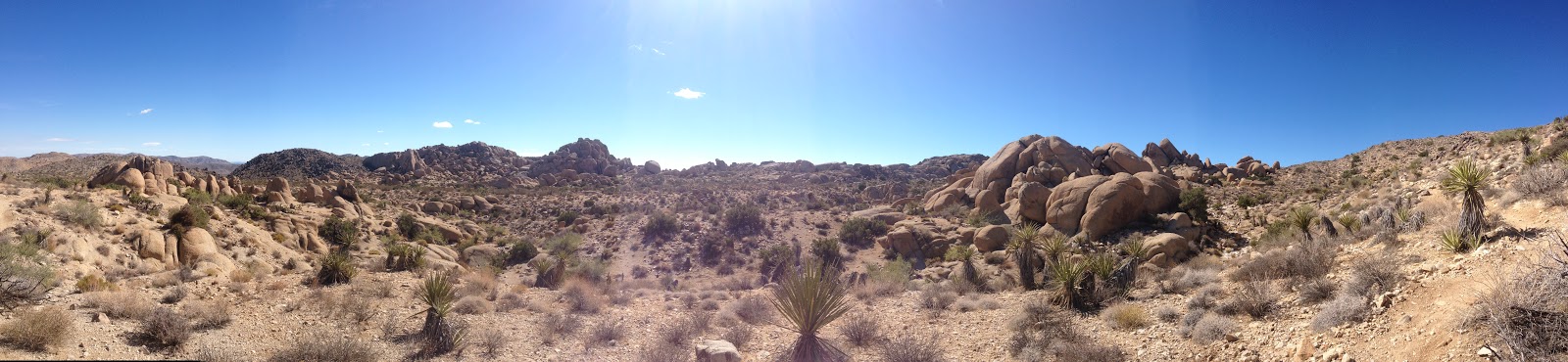
Now we have arrived in 29 Palms, and finally starting to get settled in our temporary housing (by temporary, I mean 4-6 months until housing on base is available).  I've already been getting some good runs in here, and I'm very excited to get some more.  Literally 10 minute drive from my front door is Joshua Tree National Park, that has TONS of awesome trails I have been taking advantage of, and plan to continue to do so.

This past Saturday, I did an 8-miler on a trail that combines hills, soft sand, technical single track, and scrambling through a canyon all to get to an Oasis, it was awesome.   Sunday I did a 17 miler (a first for me) through the desert in 100 degree heat climbing through washes and technical routes, and it was awesome.  This weekend is 18, and I can't wait. 

There's going to be a ton of great running, hiking, scrambling, bouldering, climbing, camping, and just being in Joshua Tree Nat'l Park.  I pretty pumped about it.  I've bought a book that describes all the trails, and if I don't want to do one of those, I'll just go off-trail and make my own.  I've already decided I want to hike and/or run every named trail in the park, and tag every peak in the time that I'll be here.  I know it will be easy over 2-3 years, so I guess I'll just have to do it multiple times, and using multiple routes.  All I know is that this is an area I'm going to get my use out of for sure.

In the meantime....Keep Running!

Thursday, September 6, 2012

Trail Runner Challenge

So I figured, before I jump into about 10 weeks of hardcore marathon training for my race in December, I'd throw in some more base training.  I saw on Twitter, that Trail Runner Magazine was doing an "ultra" challenge using the Strava app (just started using Strava by the way, and really digging the app...gives way more info than dailymile, and I just like the "dashboard" better.).  The idea is to log 100 miles from 1-16 September.  If you do, you get "extreme bragging rights" and a free issue of Trail Runner Mag (which I already subscribe to).  I just figured it was a good way to hold myself accountable and get some good base miles in before I start my next training cycle.

So far, 5 days in, and 44 miles logged...100 shouldn't be too tough.  Really, all you have to do is a 10k every day, and you'll make the challenge.  I think I'll hit over 100 miles by the time the challenge is over, but I'm not really going for any specific distance.  It's nice, because I'm at my parents house right now, and there are decent road routes and tons of city parks with different trails that are only a short drive away.  I have to say, I would have never known Indianapolis had so many parks until I became interested in trail running.  Running really does change your perception on things.

Anyway...here's to finishing the 100 mile challenge!

In the mean time...keep running!